Updates design-time support in Visual Studio 2019 and improves Chart and Map controls.
Features
- Improves design-time support in Microsoft Visual Studio 2019.
- Chart Updates
- Orientation on ItemLegend.
- LegendHighlightingMode for Hover/Click.
- PlotAreaMargin <Top, Bottom, Left, Right>.
- Added support to configure highlighting at the level of the chart rather than the individual series.
- Compressed X-Axis labelling for the TimeXAxis and OrdinalTimeXAxis.
- Automatically sync the vertical zoom to the series content.
- Added support for Annotation Layers to Stacked, Scatter, Polar, Radial and Shape series.
- Added support for highlighting to Stacked, Scatter, Polar, Radial and Shape series.
- Added HighlightingMode for all series types.
- Added SeriesHighlightingBehavior.
- Added support for overriding the data source of individual stack fragments within a stacked series.
- Added support for automatically expanding the horizontal margins of the chart based on the initial labels displayed.
- Added support for the custom style events to Stacked, Scatter, Range, Polar, Radial, and Shape series.
- All series with markers have a property called MarkerFillOpacity.
- All series with markers have a property called MarkerOutlineMode.
- Chart Defaults
- All types of charts/series have new colors for brush/fill and outlines.
- All types of charts/series have marker outlines with 2px thickness.
- All types of charts/series with markers have colored marker fill instead of white fill.
- Bar/Column/Waterfall series have outlines with 1px thickness (other series have 2px thickness).
- Bar/Column/Waterfall series have square corners instead of rounded corners.
- Point/Bubble/ScatterSeries/PolarScatter series have markers with 70% transparent fill.
- Point/Bubble/ScatterSeries/PolarScatter series have markers with solid outline that matches marker fill.
- Other series (e.g. LineSeries/ScatterLineSeries) have markers with white outlines.
- Scatter High Density series has new colors for min/max heat properties.
- Financial/Waterfall series have new colors for negative fill of their visuals.
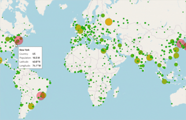
- Geospatial Map Updates
- Support for wrap around display of the map (scroll infinitely horizontally).
- Support for shifting display of some map series while wrapping around the coordinate origin.
- Support for highlighting of the shape series.
- Support for some annotation layers for the shape series.